|
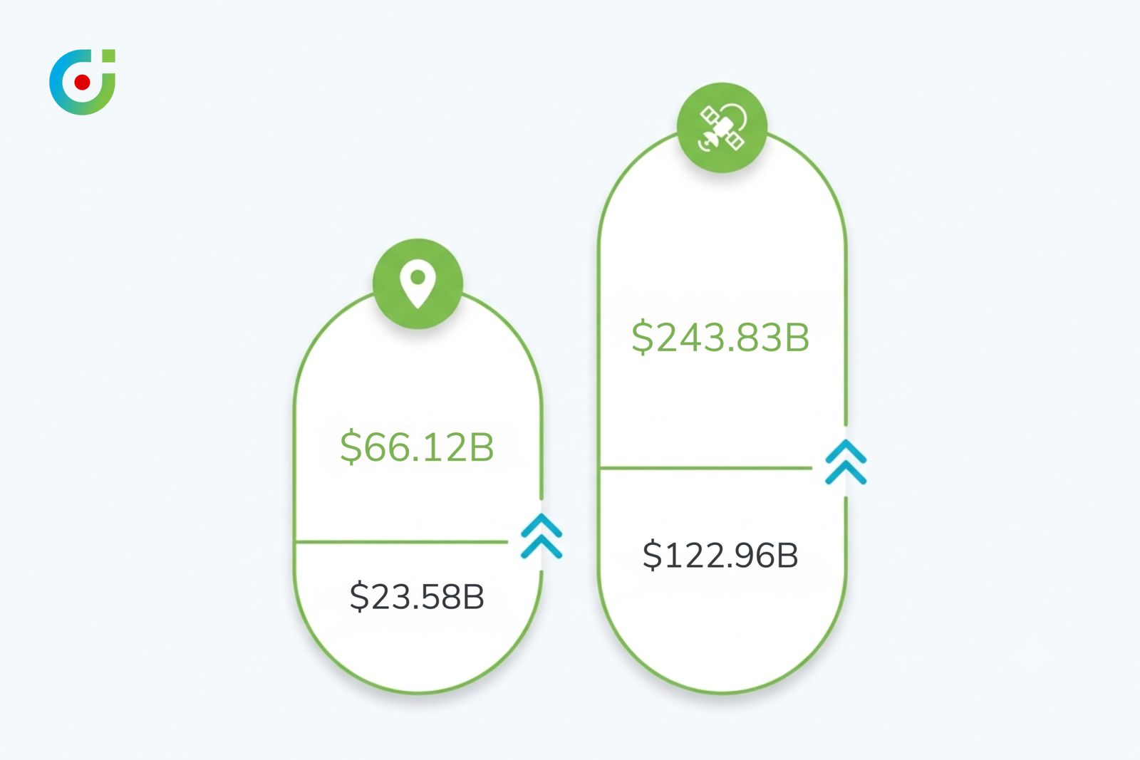
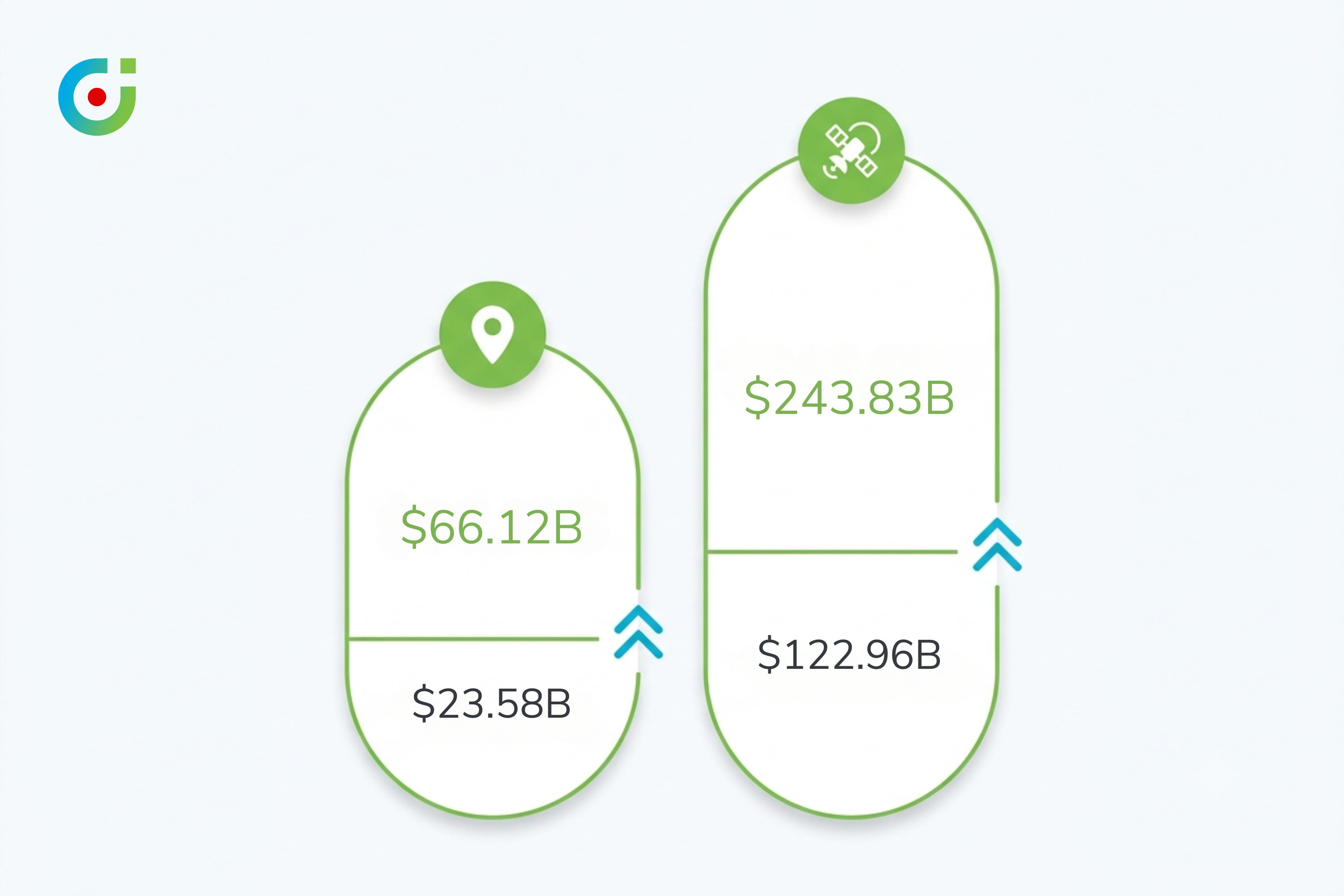
$23.58B → $66.12B
Global location intelligence market growth, 2026 to 2034, 13.8% CAGR (Fortune Business Insights)
|
$122.96B → $243.83B
Geospatial analytics market growth, 2026 to 2030 (The Business Research Company)
|
10-20%
Sales productivity gain from territory design built on real coverage data (Alexander Group)
|
5.0/5
MappyField 365 rating on Microsoft AppSource across 21 reviews
|
Ask a Dynamics 365 admin what their map integration is actually for, and most give the same answer: it plots pins on a screen so a sales manager doesn’t have to squint at a spreadsheet of zip codes. That answer isn’t wrong. It’s just years out of date. The global location intelligence market is on track to nearly triple in size: an estimated $23.58 billion in 2026, growing to $66.12 billion by 2034 [1]. That growth curve doesn’t belong to a feature anyone still calls “nice to have.” Something bigger is happening underneath the pin-drop interface most CRM admins grew up with, and 2026 is the year it gets hard to ignore.
Key Stats
| Stat | Why it matters |
|---|---|
| $23.58B → $66.12B | Global location intelligence market growth, 2026 to 2034, at a 13.8% CAGR [1] |
| $122.96B → $243.83B | Geospatial analytics market growth, 2026 to 2030 [2] |
| 10-20% | Sales productivity gain from territory design built on real coverage data [3] |
| 5.0/5 | MappyField 365’s rating on Microsoft AppSource across 21 reviews [4] |
The Conventional Wisdom: A Map Is Just a Prettier Spreadsheet
The skepticism is fair, and it didn’t come from nowhere. For most of the last decade, mapping inside Dynamics 365 meant one thing: taking a list of accounts that already existed in the CRM and drawing it on a background image so a manager could see clusters instead of rows. That’s genuinely useful, to be clear. A rep planning a week of visits gets more from six pins on a map than sixty lines in a grid. Dynamics 365 map integration earned its place in the stack on exactly that basis, fair and square.
Territory management is the clearest example. Most organizations still treat it as a once-a-year exercise: draw the boundaries, assign the accounts, export a picture of the result, move on. The map is the deliverable here, not an ongoing input. Under that view, upgrading from Bing Maps to Azure Maps, or picking a slightly nicer-looking plugin, reads as a cosmetic decision. The kind of thing that shows up in a setup guide, not a strategy memo.
Where That Framing Breaks Down
Here’s the problem with treating location as a cosmetic layer: cosmetic features don’t pull double-digit compound growth for a decade running. If dynamics 365 map integration were purely a visualization convenience, the market wrapped around it would plateau the way most UI-polish categories do. It hasn’t. Geospatial analytics alone is projected to grow from $122.96 billion in 2026 to $243.83 billion by 2030 [2], and that money isn’t being spent on prettier pins.
The productivity data tells the same story from a different angle. Territory redesign built on real coverage data delivers a 10 to 20 percent sales productivity gain [3], according to Alexander Group’s research. That’s not a rounding error attached to a decorative feature. It’s the kind of number finance teams actually ask about. Once a number like that exists, “just visualization” stops being a defensible way to talk about territory management. The conversation has to move to what the tool actually does with the data, not just how nicely it displays it.
What the Data Actually Shows: Four Location Intelligence Trends Worth Watching in 2026
Look at the market data. Look at the product announcements. Look at how buyers are actually behaving this year. Four distinct trends show up, and none of them are subtle once you know where to look.
Trend 1 — Investment Is Compounding, Not Leveling Off
Start with the money, because it sets the scale of everything else. The location intelligence market isn’t just growing. It’s growing at a rate that assumes the category becomes standard infrastructure, not an optional add-on. A 13.8% compound annual growth rate between 2026 and 2034 means the market roughly doubles every five years [1]. Geospatial analytics, the broader category location intelligence sits inside, is compounding even faster over a shorter window [2].
That kind of sustained investment doesn’t happen because buyers keep discovering prettier ways to show the same pins. It happens because location data is being wired into decisions that used to run on instinct, or on stale spreadsheets nobody trusted anyway. Once a business tastes that, it doesn’t go back.
Trend 2 — Static Pin Maps Are Giving Way to Agentic, Reasoning Systems
The most concrete signal of where this is headed came out of Google Cloud Next 2026, where Google folded live Earth AI imagery and real-time roads data directly into BigQuery AI as new geospatial analytics datasets, built to run agentic analysis against a business’s own enterprise data without manual wrangling [5]. Live satellite context and real-time disruption data now sit inside the same query layer a business already uses for its own records. Nobody draws a boundary by hand first. Nobody exports a shapefile and rejoins it later by hand. Not anymore.
> Pro tip: If your current mapping tool’s most advanced feature is a saved filter, that’s a signal, not a limitation to shrug off. The gap between “shows me where accounts are” and “tells me what that means for my pipeline this week” is exactly where agentic capability lives. That gap is widening fast.
A CRM admin might reasonably ask: does this mean the map plugin I bought two years ago is already obsolete? Not necessarily. But it does mean the evaluation question has changed. A tool that only renders geography is table stakes now, not a differentiator. So the real question before your next renewal is simple. Can the platform reason across location and business data together? Or does a person still have to do that translation by hand, every single time?
Trend 3 — Location Intelligence Is Consolidating Inside the CRM, Not Living Beside It
For years, the practical answer to “we need mapping” was a separate GIS tool. Separate login. Separate export process. Separate subscription. That pattern is reversing. Buyers increasingly expect location intelligence to be native to Dynamics 365, not bolted alongside it through a second platform (with a nightly data sync that half the team forgets even exists).
MappyField 365 is a clean example of what that consolidation looks like in practice. Territory management and live field rep tracking run inside Dynamics 365 itself, alongside route optimization. All three read and write the same records the rest of the CRM already uses. No export. No second login. No lag between what the map shows and what the CRM actually contains, ever. That’s a meaningfully different architecture from a standalone GIS layer that only happens to sync with your dynamics 365 map integration once a day.
Trend 4 — Buyers Are Judging Platforms on Real-Time Visibility, Not Static Reports
The last shift is about tempo. A territory map that gets redrawn once a year and reviewed in a quarterly deck is a report, nothing more. A live view of where field sales reps actually are right now is a different category of tool entirely, and buyers are starting to price that difference. Static reporting answers “what happened.” Real-time visibility answers “what is happening.” That second question is the one a sales manager actually has at 2pm on a Tuesday, when a rep hasn’t checked in.
A Better Framework for Evaluating Location Intelligence in 2026
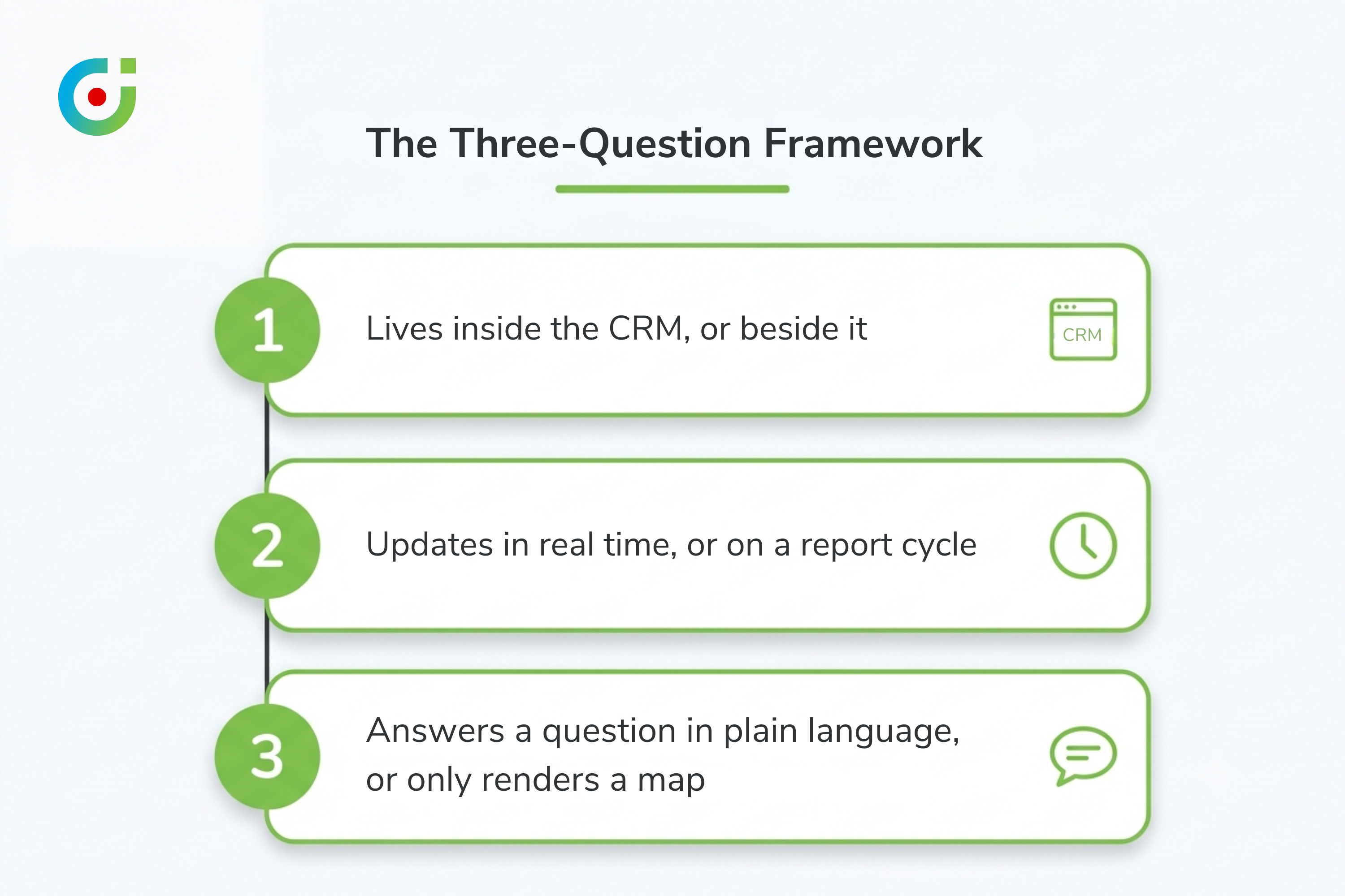
Enough diagnosis. Here’s a framework worth applying the next time anyone on your team evaluates a mapping tool, a territory plugin, or a full location intelligence platform. Three questions, asked in order.
[Image 3]
Question one: does it live inside the CRM, or beside it? If the answer involves a second login, a scheduled export, or a phrase like “syncs nightly,” you’re looking at a bolt-on, not infrastructure. Native tools read the same records your sales team already updates, in real time, with nothing lost in translation.
Question two: does it update in real time, or on a report cycle? A tool that only reflects reality as of last Tuesday’s data pull can’t answer the question a manager actually has. That question is almost always about right now. Live tracking, live check-ins, live route status: none of that is a luxury feature anymore. It’s the baseline this trend is pushing toward.
Question three: can it answer a business question in plain language, or only render a map? This is the agentic test from Trend 2, applied practically. Can someone type “which accounts in this territory haven’t been visited in 30 days” and get an answer? Or does that question still require exporting data and building a pivot table by hand?
“Isn’t this a lot to ask from what’s basically a mapping plugin?” It would have been, three years ago. It isn’t anymore, given where the category has moved. The tools that pass all three questions today aren’t exotic, either. They exist, and they’re priced for teams far smaller than the ones still running location data through a spreadsheet and a static map export.
What This Means for CRM Admins and Sales Ops Leaders
The practical takeaway here isn’t “go buy new software this quarter.” It’s narrower and more useful than that. Run your current dynamics 365 map integration through the three-question framework above before your next renewal or budget cycle, not after. Most contracts get renewed on autopilot, because nobody ever asks whether the tool kept pace with what the category can now do. Given a 13.8% compound growth rate in the underlying market, standing still is itself a decision. Even when it doesn’t feel like one.
For field sales leaders specifically, the audit is even more concrete. Pull up your current territory management view. Check whether it shows where reps actually are today, or just where they were assigned to be back at the start of the quarter. That single gap, real-time field sales visibility versus a static assignment sheet, is the clearest tell of all. It shows whether your platform is still running on 2020’s assumptions about location intelligence, or on 2026’s.
Common questions we hear on calls:
“How long does moving off a bolt-on GIS tool actually take?”
Most Dynamics 365 teams see a working native setup inside two to four weeks, not the multi-quarter migration people brace for. The heavy lifting is usually just re-mapping which fields drive territory assignment, not rebuilding anything from scratch.
“What’s the real risk if we just wait another renewal cycle?”
Nothing breaks overnight, honestly. But every quarter you wait is another quarter of running location data by hand while the market data above keeps compounding. The gap between what your team does manually and what a native, real-time tool does automatically only gets wider from here.
The Shift Worth Watching
Location intelligence spent a decade earning its reputation as a convenience feature. It was just a way to make an existing list of accounts easier to look at, nothing more dramatic than that. That reputation is now the thing holding organizations back, not describing them accurately anymore. The market data points at one conclusion. So does the agentic capability shift. So does the consolidation already underway inside Dynamics 365 itself. This stopped being a visualization checkbox somewhere along the way. It became a piece of core CRM infrastructure, and most teams haven’t updated their evaluation criteria to match, not yet anyway.
The organizations already ahead on this aren’t the ones with the fanciest map. They’re the ones that stopped asking “does it show pins” and started asking whether their platform can act on location data in real time. MappyField 365 is one working example of what that shift looks like in practice: territory management and live rep tracking, plus route optimization, running natively inside Dynamics 365 with nothing exported and nothing translated by hand. The tool’s just the mechanism, though. The mindset shift is the actual point here, and 2026 is the year it stops being optional to make.
Sources
- Fortune Business Insights, “Location Intelligence Market Size & Forecast” – https://www.fortunebusinessinsights.com/location-intelligence-market-111565
- The Business Research Company, “Geospatial Analytics Global Market Report” : https://www.thebusinessresearchcompany.com/report/geospatial-analytics-global-market-report
- Alexander Group, “Territory Design: The Gateway to Increased Sales Productivity” – https://www.alexandergroup.com/insights/territory-design-the-gateway-to-increased-sales-productivity/
- MappyField 365 on Microsoft AppSource – https://appsource.microsoft.com/en-us/product/dynamics-365/biztechcs.quick-maps
- Google Cloud, “Google Cloud Next 2026 Wrap Up”: https://cloud.google.com/blog/topics/google-cloud-next/google-cloud-next-2026-wrap-up
The post The Rise of Location Intelligence in CRM: 2026 Trends appeared first on AppJetty .
This articles is written by : Nermeen Nabil Khear Abdelmalak
All rights reserved to : USAGOLDMIES . www.usagoldmines.com
You can Enjoy surfing our website categories and read more content in many fields you may like .
Why USAGoldMines ?
USAGoldMines is a comprehensive website offering the latest in financial, crypto, and technical news. With specialized sections for each category, it provides readers with up-to-date market insights, investment trends, and technological advancements, making it a valuable resource for investors and enthusiasts in the fast-paced financial world.